The night that checking a clock could have saved the lives of 2 thousand Englishmen
mar 13 2023
On the night of October 22, 1707, an English fleet commanded by Admiral Clowdisley Shovell was returning to Great Britain coming from the Straight of Gibraltar. A heavy fog had descended, and despite the fact that they were close to the French coast, the Admiral wasn’t certain where they were. Fearing an accident because they couldn’t ascertain their exact location, he called a meeting of all of his navigators, and they arrived at a consensus: they were on the right path and if they continued sailing to the north, they would arrive safely at their destination. Unfortunately, as they neared the British Isle, they were horrified to discover that they had made a mistake. They were farther west than they had thought, in an area where there was a scattering of jagged rocky islands. The main ship, The Association, was the first to hit the rocks, and it went down immediately, followed by the others. In all, four of the five vessels in the fleet sunk in minutes, sending 2 thousand sailors to a watery grave.
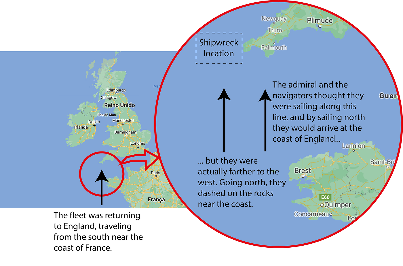
— But how did this happen? Didn’t they have a method for determining their position at sea?
They partially knew their position, because they were able to measure their latitude. However, they had no way to measure their longitude.
Let’s take a short detour here to refresh the concepts of latitude and longitude. The following figure shows, as an example, the latitude and longitude of Brasília, capital of Brazil.
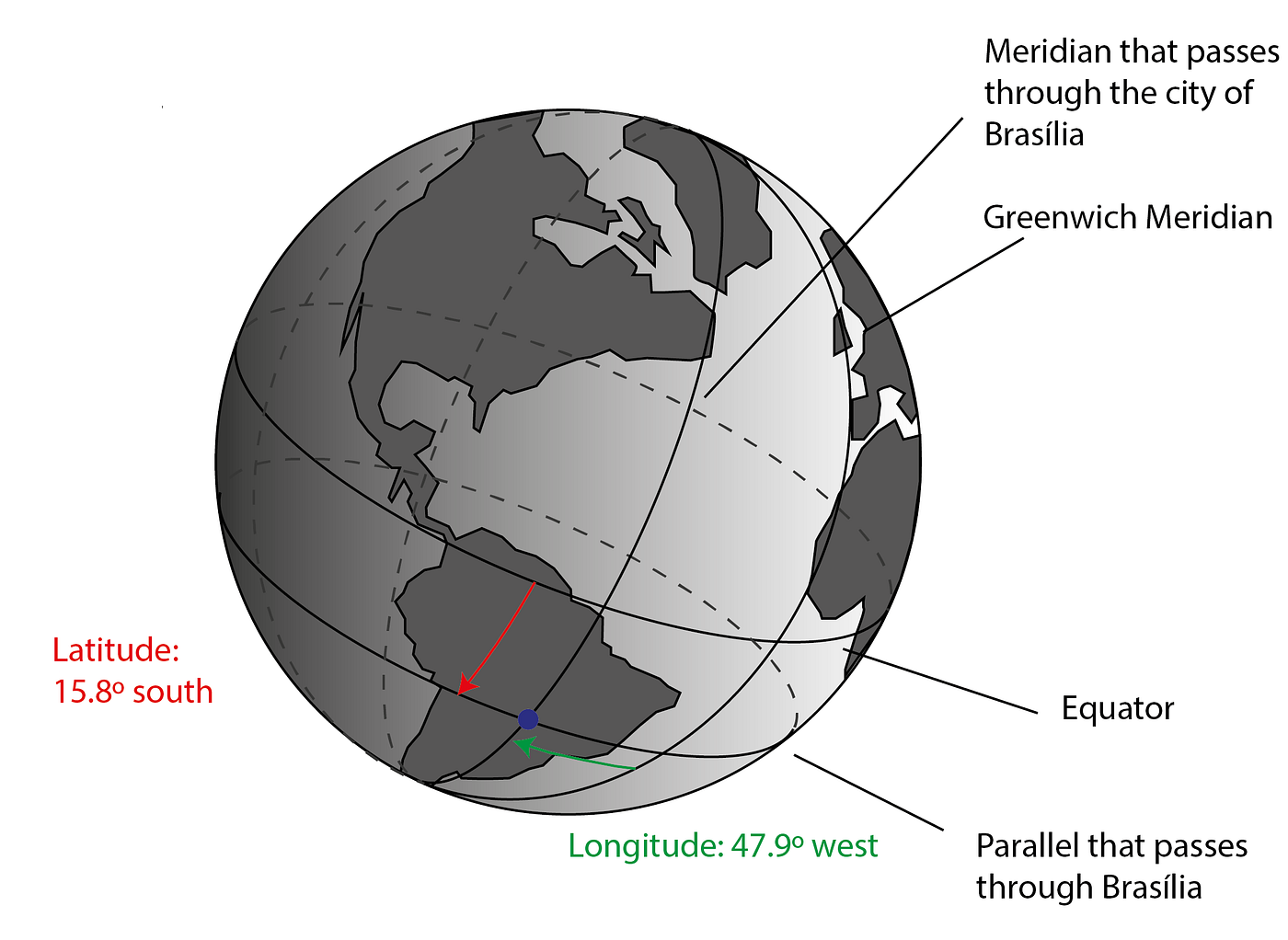
End of our detour.
Since ancient times, navigators have measured their latitude from the height of the Sun or the stars in the sky. However, longitude cannot be measured this way. Actually, there was no way to measure longitude. You can see on the map that shows the shipwreck of the English vessel that Admiral Shovell’s error was in his estimation of their longitude. He was farther west than he thought.
In the book “Shogun”, by James Clavell, which is set around the year 1600, the narrative begins with an English captain who manages to get through the Straight of Magellan and is now lost in the Pacific Ocean. Those of the crew who have survived up until that point, as well as the captain himself, are on the brink of death from lack of fresh water and food, and suffering from scurvy, the ancient plague of seafarers. The author narrates the ramblings of the captain while he scans the ocean in the hopes of seeing land:
Any voyage today was dangerous because the few navigational charts that existed were so vague as to be useless. And there was absolutely no way to fix longitude.
“Find how to fix longitude and you’re the richest man in the world,” his old teacher, Alban Caradoc, had said. “The Queen, God bless her, ’ll give you ten thousand pound and a dukedom for the answer to the riddle. The dung-eating Portuguese’ll give you more — a golden galleon. And the motherless Spaniards’ll give you twenty!
Out of sight of land you’re always lost, lad.”
So, whenever they were out of sight of land, they were lost.
— So how did they get to their destination? How were they able to navigate?
Again, in the book “Shogun”, the author explains that navigation was only possible because ship’s captains followed rutters:
A rutter was a small book containing the detailed observation of a pilot who had been there before. It recorded magnetic compass courses between ports and capes, headlands and channels. It noted the sounding and depths and color of the water and the nature of the seabed. It set down the how we got there and how we got back: how many days on a special tack, the pattern of the wind, when it blew and from where, what currents to expect and from where; the time of storms and the time of fair winds; where to careen the ship and where to water; where there were friends and where foes; shoals, reefs, tides, havens; at best, everything necessary for a safe voyage. […] But a rutter was only as good as the pilot who wrote it, the scribe who hand-copied it, the very rare printer who printed it, or the scholar who translated it. A rutter could therefore contain errors. Even deliberate ones. A pilot never knew for certain until he had been there himself. At least once.
Even when following a rutter, a captain never could be sure that he was really on the right track, because the wind, or the currents, or any number of other factors, could be different than they were when a prior voyage was made. Or the rutter could have been poorly transcribed or could be incomplete.
If it were possible to precisely determine the position of a ship, such detailed rutters wouldn’t be necessary. It would be enough just to establish the route to be taken. But this wasn’t possible because there was no way to measure longitude, which led to the sinking of countless ships, with a great death toll.
— But what exactly made measuring longitude so difficult?
In order to understand what the problem was, we have to review the actual meaning of longitude: the only thing that differentiates two points with different longitudes is the local time, given that the Sun rises at different moments as seen from these two points. For example, Brasília and La Paz are situated at practically the same latitude, but they have different longitudes. When it is noon in Brasília, it’s only 11 AM in La Paz. That’s because the Sun rises in Brasília before it rises in La Paz.

Today, when we travel to other longitudes, the first thing we do when we arrive at our destination is to adjust our watches. But this is only possible because we know the time zone of each place, defined according to its longitude, which is already known. In those days, you didn’t know the longitudes of different places, so the reverse operation had to be performed: if you knew the local time in a place on your travels, the longitude would have to be calculated by comparing it with the time in a known location that would be used as a reference.
— But that’s easy. Just bring a clock that is set to the time in the reference location. When you want to know your longitude, compare the local time with the reference. What was the problem then?
In regard to the local time, there was no great difficulty. It can be measured, for example, by following the path of the Sun in the sky. When the Sun is at its highest point, it’s noon. Starting from there, one can determine the time at other points of the day with the use of an hourglass or some other rudimentary clock.

Thus, by observing the Sun and using an hourglass, it was possible to measure local time. The difficulty arose when it came to knowing the time at the reference location, because there were no clocks that worked with precision on board of a ship.
This made the measurement of longitude impossible.
It just so happens that navigation was essential for the budding capitalistic system which was expanding across the globe, being the centerpiece of its most lucrative businesses, such as the slave trade, the commercialization of spices and sugar, and the transport of precious metals. Beginning in the XVI Century, Portugal and Spain established their dominance over the oceans. In the XVIII century, English and Dutch capitalists aggressively entered into the dispute for these routes. At this point, hundreds of ships were continuously circling the oceans and a rise in accidents followed because of the inability to measure longitude, leading to the deaths of thousands of people and resulting in huge losses to investors.
As a consequence, the measurement of longitude rose to the level of the most important scientific problem in the world in the XVIII century (that being the years of the seventeen-hundreds).
In the book Gulliver’s Travels, by Jonathan Swift, published in 1726, the narrator, Lemuel Gulliver, ponders about what his life would be like if he were immortal:
I should then see the discovery of the longitude, the perpetual motion, the universal medicine, and many other great inventions.
As you can see, he puts the “discovery of longitude” as a problem on a par with perpetual motion and a universal medicine for all diseases. In other words, as a dream, or something that could never be achieved.
But capitalist investors weren’t thinking that way: for them, the possibility of earning a lot of money would motivate someone to come up with a solution to the problem. Thus, several countries began to offer awards, the most important of them being established by the Longitude Act of 1714, through which the British parliament set a premium of 20 thousand pounds sterling for the person who could devise a precise way to calculate longitude. This was a fortune that would make the winner a very wealthy person.
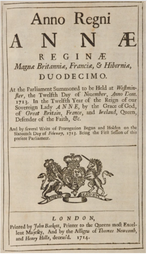
In order to claim the prize, the method would have to be able to measure longitude with a precision to within a half of a degree. Applying this criteria to the typical duration of maritime voyages, the measurement of time couldn’t deviate by more than 3 seconds every 24 hours, which is truly a very high precision requirement.
At the same time, the Longitude Board was created. This was made up of scientists and authorities of the British state, and its function was to judge the proposals presented that sought the prize.

From that point on, decades of concerted efforts were concentrated on the search for a method for measuring longitude, comparing local time with the time at a reference location, which had to be known with precision during the entire voyage.
The investigated solutions were split between two radically different approaches:
Astronomical solution: sought to identify phenomena in the sky, such as the movement of the Moon in relation to the Sun and the stars, eclipses of the moons of Jupiter, etc., which could be predicted with great precision and recorded in tables, together with the corresponding occurrence times at the reference location. With these tables and astronomical instruments, ship’s captains would be able to determine the time at the reference location. For example, knowing that at 2 AM in London, on that date, there would be an eclipse of a moon of Jupiter, the captain would observe Jupiter. When the eclipse began, he would know that it was 2 AM in London.

Mechanical solution: sought to build extremely precise clocks that could be used on ships. This solution would make the operation very simple. At any time, the captain could check the clock to ascertain the time in London.
Each of these approaches had advantages and disadvantages:
The astronomical approach had the advantage of being elegant from the point of view of scientists, because it was based on the simple observation of the universe. What’s more, it would never provide mistaken measurements due to machine defects, and would never have deviations that could accumulate over time, as can happen with clocks, because every astronomical phenomenon has its exact moment, regardless of any measurements that came before. In addition, the cost associated with this method would be relatively low, because it wouldn’t be necessary to purchase clocks, extremely expensive machines at that time. Nevertheless, there were also important disadvantages inherent in this method: the science of astronomy at the beginning of the XVIII Century still wasn’t sufficiently advanced to give the precise predictions that were needed and, even when they could provide this precision, the observations had to be made aboard a moving ship. This presented an extremely complex technical problem, given that traditional instruments for astronomical observation could only be operated while fixed to solid ground. Another problem involved the processing of the information obtained: having made the observations, the time could only be known after performing a long set of calculations, which took captains several hours, and were subject to possible errors in the process.
Meanwhile, the mechanical approach had the advantage of the simplicity of the method: all that was necessary to know the time at the reference location was to look at a clock. Easy. Longitude could be determined immediately, without any complicated calculations. The main difficulty with this method was that the technology for building such a precise clock didn’t exist. And as a secondary result of this technological difficulty, there was the problem of price: such a clock would be very expensive, because its parts would have to be built by hand, one at a time.
To pursue the astronomical solution, it would be necessary to make significant advances in the description of the stars and the planets, and improve the physics related to celestial bodies. To this end, observatories were built in various parts of the world, the most famous being the observatory of Greenwich, in London.

Observatories were also built in locations south of the Equator, such as the one on the island of Santa Helena near the coast of Africa, in order to catalog the stars in the southern hemisphere. Scientists such as Flamsteed, Halley and others dedicated decades to studying the sky, and actually ended up conceiving precise methods. Nevertheless, they didn’t solve the problem of the operational difficulty: they were never able to come up with a method for a ship’s captain to calculate his longitude by making simple observations and quick calculations.
Meanwhile, to arrive at the clock solution, it would be necessary to create new technologies. In this regard, the main difficulty involved the type of machine to be used, for the pendulum clock, the most precise at that time, simply would not work on a ship.
After years of disputes between the proponents of the two types of solutions, the proposal of the clock prevailed, as presented by the English mechanic John Harrison.

Harrison worked on his clocks for 40 years, creating technological solutions that would pave the way for precision machines from then on, such as bimetallic strips, which compensate for the effect of thermal expansion, and non-lubricated bearings, which eliminate the problem of oil viscosity variations, two factors that prevent clocks from staying precise when undergoing temperature variations. Moreover, working concurrently with physicists such as Robert Hooke, Harrison developed clocks with spring oscillators, which replaced the pendulum clocks.
The first clock he presented was the H1, developed together with his brother, James Harrison. The machine, with its individual indicators for date, time, minute, and second, weighed 25 kg, and was installed in a cube-shaped cabinet with 1.2 m on each side. Submitted to a navigation test in 1737, the machine was preliminarily considered to be satisfactory according to the criteria of the Longitude Board. Thirty years had already passed since the challenge of the prize was offered.
Even so, Harrison wasn’t satisfied with his creation. He considered it to be excessively large and to have some pending technical problems, so he requested financing to continue to develop his clock. He received the financing, and developed the improved H2 model, but he still didn’t consider it to be the solution for the problem.
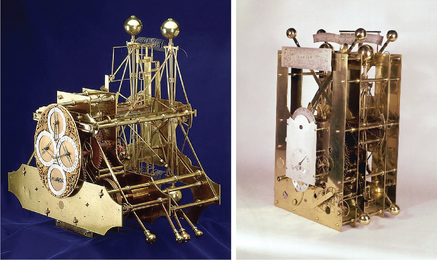
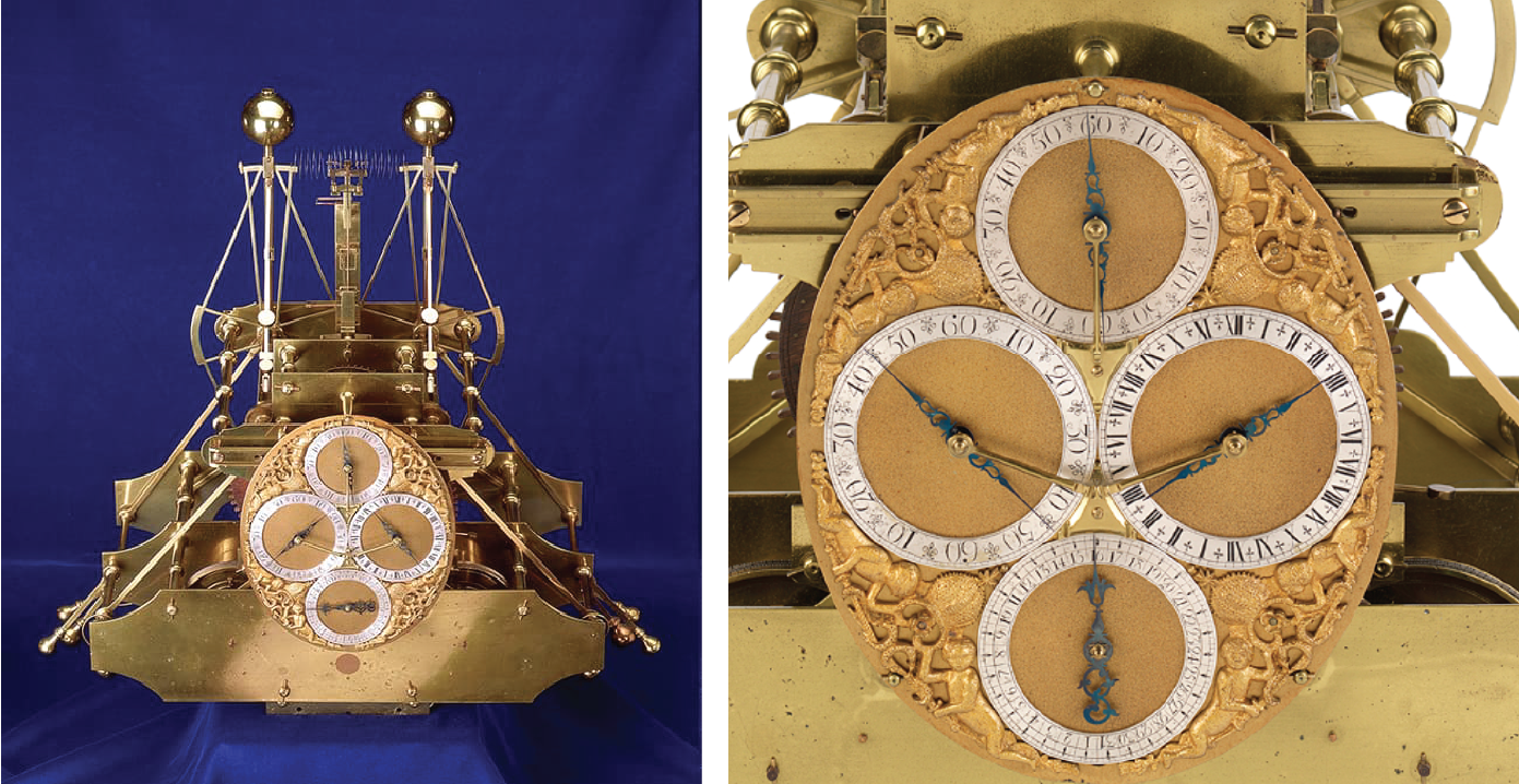
Harrison then presented his H3 model, merely to get new financing to continue.
Finally, in 1760, 53 years after the passing of the Longitude Act, he presented the H4, his masterpiece, which he considered to be the solution he had been looking for. The format was already similar to today’s analog clocks, and included parts that were made using diamonds and rubies, which allowed for almost frictionless movements.

Unfortunately for Harrison, the H4 model was ready at a time when the Longitude Board was totally dominated by astronomers who believed they were close to perfecting an astronomical solution. Mixing their interests as judges and also prize candidates, some members of this group began to impose a series of difficulties to prevent the mechanical solution from succeeding. Thus, after Harrison presented the H4, 2 years elapsed until a test voyage was authorized. The clock was then loaded onto a ship that cruised the Atlantic, to Jamaica. Over the course of a voyage that lasted 81 days, the clock lost only 5 seconds!

Unfortunately, even with this success, the Longitude Board decided that the result still wasn’t satisfactory enough and continued to impose successive conditions, such as a new test voyage in 1764, in an attempt to gain time for an astronomical solution to win acceptance. In addition, Harrison was obliged to entirely dismantle the machine in front of the representatives of the Board, and give a detailed explanation of all of the aspects of how it worked, and then reassemble it and deliver it back to them fully operational.
After he had done this, Harrison’s solution was accepted, but he only received half of the promised prize, under the allegation that he would have to produce two more clocks exactly like the H4 (without basing them on the first, which was no longer in his possession), in order to prove that the system could be duplicated. Some time later, a new demand was added: the device had to be tested by the Greenwich astronomers for 10 months, without Harrison being allowed to participate in the process.
Already elderly, and realizing he wouldn’t receive the whole prize at all, he requested an audience with King George III, to whom he pleaded his case. Finally, through intervention from the King, the parliament ended up paying John Harrison the rest of the prize money he was due. But he never officially received the award from the Longitude Board.

As a result of Harrison’s work, as well as the industrial production that was replacing craftmanship, which made machines for time measurement more affordable, captains could now navigate with certainty in regard to their position. With a precise clock to calculate their longitude, Admiral Shovell’s fleet would have arrived safely at their port, and 2 thousand lives would have been spared.
Sources:
Longitude — The True Story of a Lone Genius Who Solved the Greatest Scientific Problem of His Time (Dava Sobel)
Shogun (James Clavell)
Gulliver´s Travels (Jonathan Smith)
Board of Longitude Project — Royal Museums Greenwich
https://www.rmg.co.uk/about-us/board-longitude

I am an engineer, physics teacher, translator, and writer. I am also director of LatinLanguages, a translation agency that provides multilingual companies and final clients with translation into Portuguese and Spanish. If you work with these languages, we are your best option—delivering world-class service at Brazilian prices.
Marcos Chiquetto


